
Walk one of Europe’s most spectacular coastal trails along the unspoilt Galician coast.
Hike along rugged cliffs and windswept headlands, accompanied by the crashing Atlantic waves.
Discover magnificent sandy beaches and stay in picturesque fishing villages.
Enjoy top-class local seafood and excellent Galician wines at the local taverns.
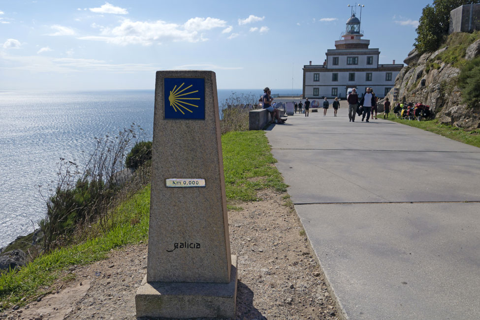
Complete an epic hike by finishing at the ‘end of the world’ in Finisterre.
Hiking the Camiño dos Faros (Lighthouse Way)
Self-guided walking holiday with luggage transportation
The Camiño dos Faros (Lighthouse Way) is a 200 km path along Galicia’s rugged Costa da Morte (Coast of Death) finishing at Finisterre (literally meaning ‘the end of the word’). The trail was developed in 2013 by a group of locals who set out to create a coastal walking route from Malpica to Finisterre, connecting all the lighthouses along the way. They connected clifftop fisherman’s trails and quiet country roads with stretches along wide empty beaches to create a truly spectacular coastal hike.
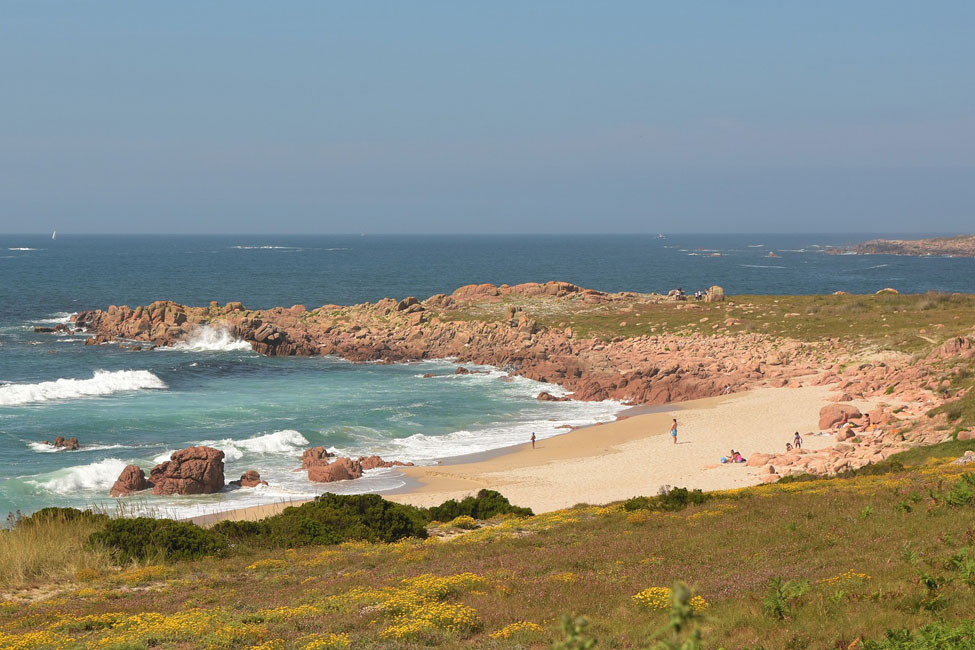
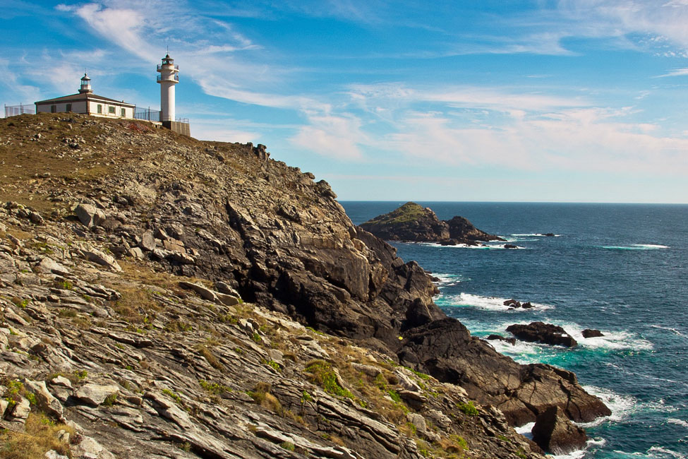
As the name suggests, you will pass a string of lighthouses as you make your way southwards along Galicia’s beautiful coastline. These are invariably perched on windswept headlands jutting out into the wild Atlantic Ocean. The Costa da Morte is so named because of the numerous shipwrecks that have happened offshore along this perilous stretch of coast. The Costa da Morte is indeed dangerous for sailors but paradise for hikers. The scenery along the Camiño dos Faros is often breathtaking. When not walking along dramatic cliff edges, you will be scaling headlands or dunes for wonderful views over the undisturbed beaches and coves below.
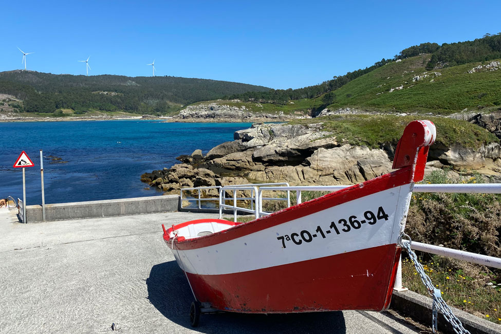
The Camiño dos Faros is not a pilgrimage route like the Camino de Santiago. Rather, the Lighthouse Way has been created by hikers and is a much wilder and more exhilarating experience than the more famous caminos. It is also still relatively undiscovered. On most days you will not meet many fellow hikers, you will be accompanied by the sounds of sea birds and crashing waves. The Costa de Morte has remained largely untouched by tourism, so you will find the most beautiful wide beaches that remain largely empty even in the summer season. You will stay in sleepy fishing villages and dine on delicious fresh seafood washed down by a glass or two of the excellent Galician white wine!
“Rocky headlands, winding inlets, small fishing towns, plunging cliffs, wide sweeping bays and many a remote, sandy beach – this is the eerily beautiful ‘Coast of Death’, the most westerly outpost of mainland Spain, where mysteries and legends abound”. Lonely Planet
| 8 DAYS / 7 NIGHTS | From €620 per person sharing*
*A high season supplement will apply during peak booking periods |
||||||||||||||||||
| 11 DAYS / 10 NIGHTS | From €850 per person sharing*
*A high season supplement will apply during peak booking periods |
||||||||||||||||||
| ACCOMMODATION |
The hotels on this trip have been carefully selected for their location, atmosphere and/or unique services. All rooms are en-suite. Some of the hotels we work with appear here. If a certain hotel is unable to confirm due to lack of availability, we will request a similar one and inform you about the alternative booked.
NOTE: On day 10 you can upgrade to the tiny design hotel at the Cape: Hotel Semáforo de Fisterra (located in Finisterre). You can also book another night in Finisterre to enjoy an afternoon at the beach after you have completed the loop walk to the cape in the morning. For summer bookings the extra night in Finisterre is compulsory.
|
||||||||||||||||||
| AVAILABILITY | You can start on any day of the week, subject to availability, from April 1st to October 5th. | ||||||||||||||||||
| INCLUDED |
|
||||||||||||||||||
| NOT INCLUDED |
|
||||||||||||||||||
| OPTIONAL EXTRAS |
|
||||||||||||||||||
| DIFFICULTY | The difficulty level of this trip is rated as moderate overall. The Camiño dos Faros is well signposted, with arrows and green footprints painted on the rocks along the way. There are some steep ascents and descents and the route is quite exposed so not suitable for anyone who suffers from vertigo. Galician fishermen specialise in fish and shellfish that are difficult to capture and often live at the foot of the cliffs. They are trained to follow these paths, but that doesn’t mean they are easy. You need to have firm legs, good eyes and be reasonably fit to do this trail. We have therefore reduced some of the daily stages by adding taxi transfers and describing shortcuts to avoid unnecessary loops or stretches with excessive ascent and descent. | ||||||||||||||||||
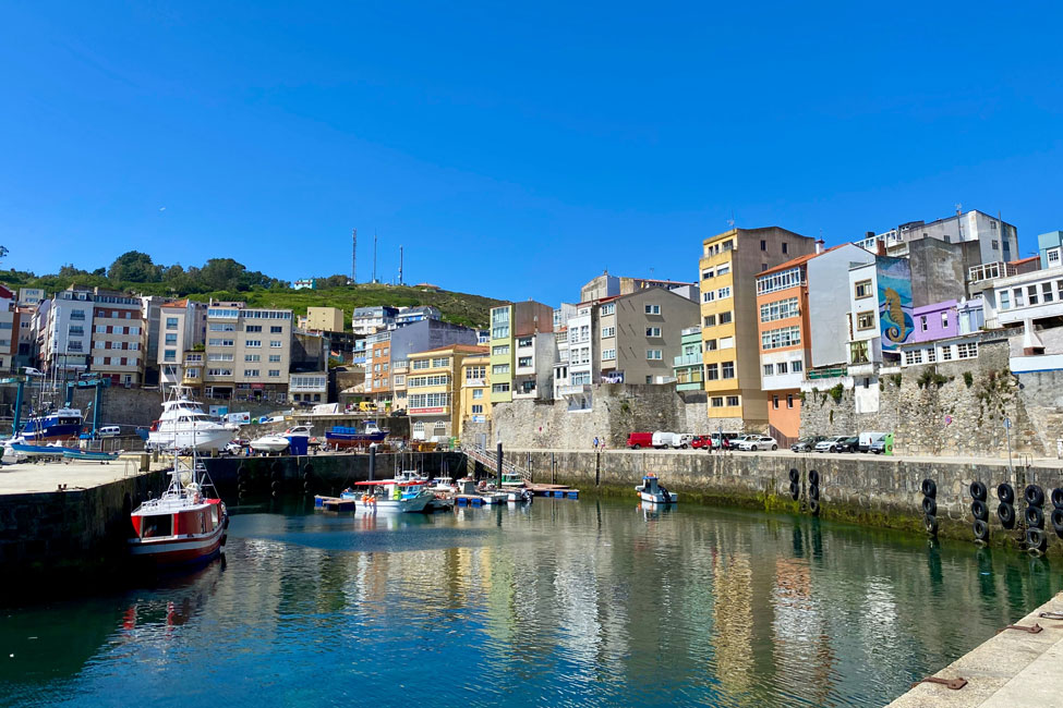
Day 1: Arrival in Malpica de Bergantiños
Arrival in Malpica, a Galician fishing port town with a great seafaring tradition. You can get there by bus or taxi from A Coruña. Once you’ve checked into your hotel, you can take a stroll around the busy old port before choosing a restaurant for a delicious seafood dinner.
Overnight: Malpica
Day 2: From Malpica to Barizo
Distance: 13 km | Ascent: 400 m | Descent: 400 m | Walking time: 5 hrs approx.
On your first walking day you will get a good idea of what lies ahead of you on the rest of the Lighthouse Way. Leaving Malpica, you will follow a mixture of gravel roads and narrow footpaths along the Galician coast. The route is exposed and uneven in parts but very scenic. You will pass unspoilt sandy beaches and a viewpoint to the offshore Sisargas islands. This is also where you will spot your first lighthouse. The Faro das Sisargas is on an island about a kilometre from the coast. Built in the 1850s it’s the second oldest lighthouse on the Costa del Morte.
The route ends at the door of your charming rural hotel in an idyllic location, next to the sea and close to the beach of Seiruga, one of the best-known beaches in the Costa da Morte. Dinner is not included tonight because the hotel only services ‘a la carte’ menus. You might also want to try next door’s Michelin star restaurant “As Garzas” (but remember to book in advance).
Overnight: Barizo.
Day 3: Circular from Barizo via Faro Nariga
Short route: 13 km | Ascent: 620 m | Descent: 620 m | Walking time: 5 hrs approx.
Long route: 17 km | Ascent: 720 m | Descent: 720 m | Walking time 6½ hrs approx.
Today’s hike takes you first to the Faro Nariga, one of the most famous lighthouses of the Costa da Morte. This is actually the most modern lighthouse on the route. It was built in 1998 and designed by the renowned architect César Portela. The lighthouse is surrounded by large rocks in all sorts of weird and wonderful shapes. You continue to the beautiful beach of Niñons, from where you can either take a taxi back to Barizo or walk back along gravel roads that give access to a modern windmill park.
Overnight: Barizo.
Day 4: From Roncudo to Ponteceso
High Route: 14.5 km | Ascent: 325 m | Descent: 450 m | Walking time: 4½ hrs approx.
Low Route: 18 km | Ascent: 525 m | Descent: 650 m | Walking time: 6½ hrs approx.
To avoid a long and steep stretch through a vast empty area, a pre-arranged local taxi will take you after breakfast to the tiny hamlet of Roncudo. From there you either follow the Camiño along winding footpaths to the lighthouse at Cabo Roncudo (after which you follow a quiet road for 3 km to the fishermen’s village of Corme) or you take a shortcut to Corme.
After a coffee break at Corme you have a choice of routes once again. You can either follow the long spectacular Camiño route along the coast (with some exposed parts), or a shorter route through peaceful forest followed by a long stretch through sand dunes and salt marshes as you approach Ponteceso. A pre-arranged taxi will take you from here to your modern beach hotel in Laxe.
before reaching the extensive sand plateau that separates the river mouth of Ponteceso from the Atlantic Ocean. Finally, a long stretch of sandy trail before you reach Ponteceso and a taxi will take you to your modern beach hotel in Laxe.
Overnight: Laxe.
Day 5: From Laxe to Camelle harbour
Distance: 15 km | Ascent: 485 m | Descent: 485 m | Walking time: 5½ hrs approx.
Today’s walk is relatively easy and features lovely and varied scenery. A beautiful stretch of coastline and one steep hill separates Laxe from the large sandy beach of Traba. It’s worth the climb to the hilltop of O Peñon for the wonderful view over the Praia do Soesto. Continuing to Praia de Traba, the high sand dunes here shelter a lagoon that is home to a great diversity of birds.
After a swim or a meal at the only bar-restaurant along today’s route, you follow an old coastal ox-trail which has been literally carved out of the granite rock and winds its way around the strange wind-sculptured rock formations. There is no hotel in Camelle, so a pre-arranged taxi will pick you up and take you back to your accommodation in Laxe.
Overnight: Laxe.
Day 6: From Arou to Camariñas
Distance: 16 km | Ascent: 420 m | Descent: 420 m | Walking time: 5½ hrs approx.
After breakfast a pre-arranged taxi will take you to the seaside village of Arou, where you start today’s hike. This is a rugged and exhilarating route. The first section is quite arduous, as you pass two small harbours reminiscent of smugglers’ coves, before climbing up the back of the immense sand dune of Monte Branco. A truly wild and unspoilt coastal stretch then lies ahead, as you descend and cross a chain of small beaches called Praias de Trece. Very shortly afterwards you come to the Cementerio de los ingleses (Cemetery of the English); a symbolic burial place to honour the lives of sailors and passengers that died in three shipwrecks that happened along this coast between 1883 and 1893. The route becomes much easier from this point. You follow a gravel track and coastal paths to the hamlet of Mourin, then a quiet country road into Camariñas.
NOTE: For those who are afraid of heights or on days with strong winds, there is an alternative high route starting near Sta Mariña, that offers the view across the Praia do Trece before you reach the cemetery. That route is less exposed and is 14 km.
Overnight: Camariñas / Mourin, depending on availability (If your accommodation is in Mourin, the walk will be 2 km shorter).
Day 7: Camariñas loop walk
Distance: 13.5 km | Ascent: 400 m | Descent: 400 m | Walking time: 5 hrs approx.
As you walk back to the coast via Mourin, you will be surprised by the dramatic location of the most imposing lighthouse on the route: the Cabo Vilán. Jutting out into the Atlantic Ocean atop a 100-metre-high rocky promontory, this is undoubtedly a highlight of the Camiño dos Faros. Vilán lighthouse was in fact the the first electrified lighthouse in all of Spain. The lighthouse now contains a visitor centre and café, so you can stop for refreshment before continuing your walk along the coast. You will pass a wonderful viewpoint at the hilltop chapel Ermida da Virxe do Monte on your way back to the port town of Camariñas. Today’s route is relatively short, which allows you to have a longer lunch at Restaurant Puerto Arnela. The traditional village architecture has suffered from modernity, but it houses a small museum dedicated to the typical handcrafted lace of Camariñas.
Overnight: Camariñas / Mourin.
Day 8: Departure from Camariñas / Mourin
After breakfast an included taxi transfer will take you to Vimianzo, where you can catch a bus to either A Coruña or to Santiago.
Day 1: Arrival in Malpica de Bergantiños
Arrival in Malpica, a Galician fishing port town with a great seafaring tradition. You can get there by bus or taxi from A Coruña. Once you’ve checked into your hotel, you can take a stroll around the busy old port before choosing a restaurant for a delicious seafood dinner.
Overnight: Malpica
Day 2: From Malpica to Barizo
Distance: 13 km | Ascent: 400 m | Descent: 400 m | Walking time: 5 hrs approx.
On your first walking day you will get a good idea of what lies ahead of you on the rest of the Lighthouse Way. Leaving Malpica, you will follow a mixture of gravel roads and narrow footpaths along the Galician coast. The route is exposed and uneven in parts but very scenic. You will pass unspoilt sandy beaches and a viewpoint to the offshore Sisargas islands. This is also where you will spot your first lighthouse. The Faro das Sisargas is on an island about a kilometre from the coast. Built in the 1850s it’s the second oldest lighthouse on the Costa del Morte.
The route ends at the door of your charming rural hotel in an idyllic location, next to the sea and close to the beach of Seiruga, one of the best-known beaches in the Costa da Morte. Dinner is not included tonight because the hotel only services ‘a la carte’ menus. You might also want to try next door’s Michelin star restaurant “As Garzas” (but remember to book in advance).
Overnight: Barizo.
Day 3: Circular from Barizo via Faro Nariga
Short route: 13 km | Ascent: 620 m | Descent: 620 m | Walking time: 5 hrs approx.
Long route: 17 km | Ascent: 720 m | Descent: 720 m | Walking time 6½ hrs approx.
Today’s hike takes you first to the Faro Nariga, one of the most famous lighthouses of the Costa da Morte. This is actually the most modern lighthouse on the route. It was built in 1998 and designed by the renowned architect César Portela. The lighthouse is surrounded by large rocks in all sorts of weird and wonderful shapes. You continue to the beautiful beach of Niñons, from where you can either take a taxi back to Barizo or walk back along gravel roads that give access to a modern windmill park.
Overnight: Barizo.
Day 4: From Roncudo to Ponteceso
High Route: 14.5 km | Ascent: 325 m | Descent: 450 m | Walking time: 4½ hrs approx.
Low Route: 18 km | Ascent: 525 m | Descent: 650 m | Walking time: 6½ hrs approx.
To avoid a long and steep stretch through a vast empty area, a pre-arranged local taxi will take you after breakfast to the tiny hamlet of Roncudo. From there you either follow the Camiño along winding footpaths to the lighthouse at Cabo Roncudo (after which you follow a quiet road for 3 km to the fishermen’s village of Corme) or you take a shortcut to Corme.
After a coffee break at Corme you have a choice of routes once again. You can either follow the long spectacular Camiño route along the coast (with some exposed parts), or a shorter route through peaceful forest followed by a long stretch through sand dunes and salt marshes as you approach Ponteceso. A pre-arranged taxi will take you from here to your modern beach hotel in Laxe.
before reaching the extensive sand plateau that separates the river mouth of Ponteceso from the Atlantic Ocean. Finally, a long stretch of sandy trail before you reach Ponteceso and a taxi will take you to your modern beach hotel in Laxe.
Overnight: Laxe.
Day 5: From Laxe to Camelle harbour
Distance: 15 km | Ascent: 485 m | Descent: 485 m | Walking time: 5½ hrs approx.
Today’s walk is relatively easy and features lovely and varied scenery. A beautiful stretch of coastline and one steep hill separates Laxe from the large sandy beach of Traba. It’s worth the climb to the hilltop of O Peñon for the wonderful view over the Praia do Soesto. Continuing to Praia de Traba, the high sand dunes here shelter a lagoon that is home to a great diversity of birds.
After a swim or a meal at the only bar-restaurant along today’s route, you follow an old coastal ox-trail which has been literally carved out of the granite rock and winds its way around the strange wind-sculptured rock formations. There is no hotel in Camelle, so a pre-arranged taxi will pick you up and take you back to your accommodation in Laxe.
Overnight: Laxe.
Day 6: From Arou to Camariñas
Distance: 16 km | Ascent: 420 m | Descent: 420 m | Walking time: 5½ hrs approx.
After breakfast a pre-arranged taxi will take you to the seaside village of Arou, where you start today’s hike. This is a rugged and exhilarating route. The first section is quite arduous, as you pass two small harbours reminiscent of smugglers’ coves, before climbing up the back of the immense sand dune of Monte Branco. A truly wild and unspoilt coastal stretch then lies ahead, as you descend and cross a chain of small beaches called Praias de Trece. Very shortly afterwards you come to the Cementerio de los ingleses (Cemetery of the English); a symbolic burial place to honour the lives of sailors and passengers that died in three shipwrecks that happened along this coast between 1883 and 1893. The route becomes much easier from this point. You follow a gravel track and coastal paths to the hamlet of Mourin, then a quiet country road into Camariñas.
NOTE: For those who are afraid of heights or on days with strong winds, there is an alternative high route starting near Sta Mariña, that offers the view across the Praia do Trece before you reach the cemetery. That route is less exposed and is 14 km.
Overnight: Camariñas / Mourin, depending on availability (If your accommodation is in Mourin, the walk will be 2 km shorter).
Day 7: Camariñas loop walk
Distance: 13.5 km | Ascent: 400 m | Descent: 400 m | Walking time: 5 hrs approx.
As you walk back to the coast via Mourin, you will be surprised by the dramatic location of the most imposing lighthouse on the route: the Cabo Vilán. Jutting out into the Atlantic Ocean atop a 100-metre-high rocky promontory, this is undoubtedly a highlight of the Camiño dos Faros. Vilán lighthouse was in fact the the first electrified lighthouse in all of Spain. The lighthouse now contains a visitor centre and café, so you can stop for refreshment before continuing your walk along the coast. You will pass a wonderful viewpoint at the hilltop chapel Ermida da Virxe do Monte on your way back to the port town of Camariñas. Today’s route is relatively short, which allows you to have a longer lunch at Restaurant Puerto Arnela. The traditional village architecture has suffered from modernity, but it houses a small museum dedicated to the typical handcrafted lace of Camariñas.
Overnight: Camariñas / Mourin.
Day 8: Cereixo to Muxia
Distance: 14.5 m | Ascent: 570 m | Descent: 600 m | Walking time: 5½ hrs approx.
Or a longer route with extension to Muxia lighthouse and the Santuario da Virxe da Barca:
Distance: 17 km | Ascent: 620 m | Descent: 620 m | Walking time: 6½ hrs approx.
After breakfast you will have a short taxi transfer to Cereixo, for the start of today’s walk to Muxia.
After the previous days of wild coastal landscapes and crashing Atlantic waves, the start of today’s route is a lot more quiet and serene. You begin by following the river Porto to its mouth, accompanied by the sights and sounds of large groups of marisqueiras collecting mussels and shellfish. The sight of the small Lago lighthouse indicates that you’re back to the Atlantic coast and close to the beach of Lago (with several bars and restaurants). This is a good place to stop for a lunch or a cold drink (or a swim). Fully refreshed, you are then ready to tackle the steep ascent to the village of Mereixo. Here you briefly join the Camino de Santiago trail to Finisterre but the Camiño dos Faros soon diverges again via a beautiful path through lush riverside vegetation back to the coast. You finally enter Muxia via the beach. If you still have some energy for walking, you can take a loop walk to the end of the peninsula and the Nosa Señora da Barca church and lighthouse.
Overnight: Muxia.
Day 9: From Moreira to Queiroso
Distance: 15 km | Ascent: 520 m | Descent: 500 m | Walking time: 5½ hrs approx.
To avoid 3 km of road walking and the crossing of 3 small ‘fjords’ with very steep ascents and descents, you ride partway with the taxi that transports your luggage.
From the little hamlet of Moreira, you walk to the beach and continue along the coastline to the Touriñán Lighthouse, the westernmost point of mainland Spain. The landscape today is actually quite reminiscent of the west coast of Ireland. From Touriñán, you turn southwards and make your way to the stunningly beautiful surfers’ beach of Nemiña. This is the perfect place to stop for lunch before walking the last 2 km to Queiroso and your rural hotel run by an excellent local chef.
Overnight: Near Queiroso in a rural hotel. Dinner tonight is included.
Day 10: From Castrexe to Finisterre
Distance: 20 km | Ascent: 820 m | Descent: 780 m | Walking time: 8 hrs approx.
Or shorter route (Starting at Playa Arnela):
Distance: 14 km | Ascent: 625 m | Descent: 665 m | Walking time: 6 hrs approx.
Your last walking day is again a spectacular route, especially the final stretch between Praia Arnela and Finisterre where you follow the coastline along the cliffs and appreciate the skill and bravery of the fishermen who stand on exposed corners to get the best catch. The section between Castrexe and Praia Arnela can be skipped, but then you will miss the last 1.5 km of quiet sandy beach before Finisterre.
Don’t let the total distance discourage you. Even the full distance of 20 km becomes very manageable if you first walk to your hotel in Finisterre and check in, take a shower and postpone the last and the most symbolic part of the Camiño to later that evening or very early next morning. Cape Finisterre (Cabo Fisterra) is especially magical at dawn or sunset. The loop-walk to the cape is approximately 7.5 km, with 330 metres of ascent and descent. Although the walk back to the town of Finisterre along the road is a bit of an anti-climax, you will share it with pilgrims who’ve often come a very, very, long way and who’s faces glow with satisfaction and emotion as they have completed their epic journeys to ‘the end of the world’: Finis-terrae.
Overnight: Finisterre.
Day 11: Departure from Finisterre
Your walking holiday along the Camiño dos Faros comes to an end after breakfast this morning. You can take a bus to Santiago for onward travel.
Getting to Malpica
Departure from Finisterre (11-day tour)
| From Fisterra to La Coruña airport
Bus from Fisterra to Santiago (4 times a day, 2½ hours), then bus to A Coruña (every half hour, travel time about 1 hour). From there, bus or taxi to A Coruña airport. For more information, please go to: www.monbus.es/en/galicia/routes-regional From Fisterra to Santiago de Compostela airport Bus from Fisterra to Santiago (4 times a day, 2½ hours), then shuttle from Santiago city centre to Santiago airport (*) NOTE: Private taxi transfers can be booked from / to the airport (A Coruña or Santiago de Compostela). Rates on request. |
|
| Returning to Malpica to collect your car
By bus from Fisterra to Santiago (2½ hours, 4 services a day) then from Santiago to A Coruña (every half hour, travel time about 1 hour). From A Coruña, regional bus to Malpica (5 per day, travel time about 1½ hours). Keep in mind that these connections will take you most of day. For more information, please go to: www.monbus.es/en/galicia/routes-regional |
Departure from Camariñas / Mourin (8-day tour)
| If you finish in Camarinas / Mourin, an included taxi transfer will take you to Vimianzo, where you can catch a bus to either A Coruña or to Santiago. |


Tour Reviews
A great tour, very well organised, spectacular coast, rocks, beaches and views.
Leave a Review